Israel Hiking Map 9.20.2
Free Version
Publisher Description
Israel Hiking Map - Your navigation companion for the Israel outdoors
Israel Hiking Map is a powerful, yet simple to use, navigation and route-planning tool for the outdoors.
Geared towards hikers, bikers and off-road drivers it keeps you oriented in the Israeli backcountry even with no cellular reception. Use crisp topographic maps to navigate, familiarize with nearby points of interest, plan, import and share routes, synchronize effortlessly with our trip-planning site and much more.
Here’s what you get for free:
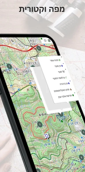
Maps
- Vector maps with unlimited zoom with no loss of quality
- A hiking map, complete with blazed trails.
- A biking map, compete with single tracks marked for difficulty and marked bike routes.
- Hebrew and English versions of all maps
- Text labels that orient to the viewers’ perspective
- A satellite image
- Transparent map overlays to show topography and trails over the sat image
Depth perception
- High resolution contour lines based on spatial data from NASA
- Dynamic hill-shading which changes as the map rotates for accurate
depth perception at a glance
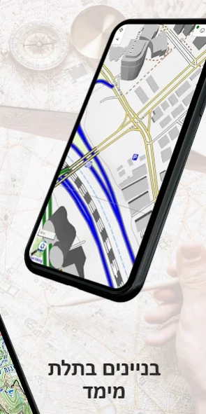
- 3D models of many buildings in urban areas
Navigation
- Show your position and direction
- Orient the map north or in your direction of movement
- Record your path as you travel
- Analyze your speed and distance traveled
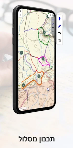
Routes
- Search for nearby routes for walking, driving and biking
- Plan your own routes – they would automatically follow the roads and paths on the map
- Manipulate routes – reverse, split or merge them at will
- Handle several routes at once
- Effortlessly synchronize with the routes you plan on our website
- Share routes or save them on your phone
- Analyze the height profile of routes
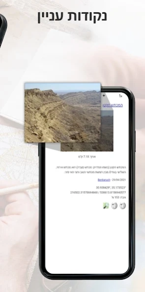
Points of interest
- An extensive list of historical sites, tourist attractions, campsites, springs and viewpoints to visit
- Easy access to geo-located articles from Wikipedia and iNature
- Easily add your own POIs to the map
Offline map purchase
You can buy a yearly subscription to our offline maps. Use them when you are out of reception or want to save your battery. The maps are continuously updated.
About Israel Hiking Map
Israel Hiking Map is a free app for Android published in the Geography list of apps, part of Education.
The company that develops Israel Hiking Map is Israel Hiking. The latest version released by its developer is 9.20.2.
To install Israel Hiking Map on your Android device, just click the green Continue To App button above to start the installation process. The app is listed on our website since 2024-04-02 and was downloaded 9 times. We have already checked if the download link is safe, however for your own protection we recommend that you scan the downloaded app with your antivirus. Your antivirus may detect the Israel Hiking Map as malware as malware if the download link to il.org.osm.israelhiking is broken.
How to install Israel Hiking Map on your Android device:
- Click on the Continue To App button on our website. This will redirect you to Google Play.
- Once the Israel Hiking Map is shown in the Google Play listing of your Android device, you can start its download and installation. Tap on the Install button located below the search bar and to the right of the app icon.
- A pop-up window with the permissions required by Israel Hiking Map will be shown. Click on Accept to continue the process.
- Israel Hiking Map will be downloaded onto your device, displaying a progress. Once the download completes, the installation will start and you'll get a notification after the installation is finished.
